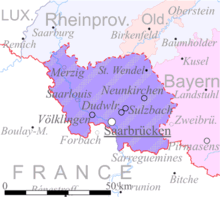
Territory of the Saar Basin
League of Nations Mandate in Weimar Republic (1920–35)The Territory of the Saar Basin was a region occupied and governed by the United Kingdom and France from 1920 to 1935 under a League of Nations mandate. It had its own flag : a blue, white, and black horizontal tricolour. The blue and white stood for Bavaria, and white and black for Prussia, out of whose lands the Saar Territory was formed. Initially, the occupation was under the auspices of the Treaty of Versailles. Its population in 1933 was 812,000, and its capital was Saarbrücken. The territory closely corresponds with the modern German state of Saarland, but was slightly smaller in area. After a plebiscite was held in 1935, it was returned to Germany.
Read article
Top Questions
AI generatedMore questions
Nearby Places

Reisbach (Saar)
Town in Germany

Saarwellingen
Municipality in Saarland, Germany

Nalbach
Municipality in Saarland, Germany

Schmelz
Municipality in Saarland, Germany
Paratrooper Battalion 261 (Bundeswehr)
Military unit

Düppenweiler
Ortsteil of Beckingen in Saarland, Germany

Grube Düppenweiler

Theel
River in Germany


